Most of us have seen the Gleason map. Also the curious scale that seems to be torn off at the 33 latitude. It appears to be torn off at 33° , but actually it is torn somewhere at 25°. But on first glance it seems to be at 33°. This seems to be a deliberate act by somebody (probably Gleason himself) to convey a message. If you consider the 90° angle of the scale edges, you get an arrow, which seems to be pointing at......Egypt.
Why?
The obvious answers points to the Jesuit-Freemasons angle. The Freemason symbol also has a 90° angle to it.
This picture of the torn off scale is trying to tell us something about the Flat earth.
The curious cut-off stub on the Gleason map scale
There are other mysteries hidden in the Gleason map. The two triangular notches at the top seem to be pointing to something. The two videos below attempts at explaining this:
The following will take your mind for a spin. Seeing as there are so many flat earth stuff we still need concrete proof on, getting any kind of proof for the following will require a budget in the billions, something only a "space" agency like Nasa can have. The reason I am posting this is that it will keep your mind flexible enough to handle something like the flat earth. So grab a cuppa or a beer and read this. Please treat the following as interesting fiction. Before we can arrive at certain concrete proofs as to our flat earth realm, we need to stretch those brian muslces enough to consider even the most fantastic and far fetched possibilities. Why? Because we may be unaware of certain aspects of our reality as yet. It is either that , or be like the glober-heads, happy and safe in the shade of what Nasa dishes out as the truth.
The supposed international security around the Antarctic may not be for what you think it is. The security may be there not to prevent you from discovering the glass dome of the firmament as it touches the earth , but to keep you from knowing the truth: that the land continues on beyond the Antarctic to fantastic continents beyond. At least if you believe Amadeo Giannini and the writings in his book "Worlds Beyond The Poles".
I liked the book inasmuch as the fantastic 'new' theory it propounds . But try as much as I could , I found it difficult to wrap my head around certain tough areas. For example, in the few chapters I read, Giannini mentions that there is land beyond both the Antarctic AND the Arctic! I can understand there being land beyond the Antarctic on the flat earth map. We have all seen those supposedly ancient Japanese or Chinese map that shows vast continents spread around the Antarctic circle.
On the above map, there is NO land beyond the Arctic, as it is the central Northern point of our flat circular Earth. Not unless the map is wrong and the earth is actually more spread out across the Arctic circle. Which could explain those long flight times between Anchorage and Oslo. Or maybe Youtuber Zhib Rhan is correct and the flat earth map should be reverse with the Antarctic in the centre and the Arctic on the outer ring. Like this:
(U.N. flat Earth map is wrong! check out flights Oslo2Anchorage and Moscow2Anchorage)
But Giannini's model is different from both models in that it predicts land beyond BOTH the poles! Nor does he mention eastern circumnavigation. How is that if one travels east he reaches back to his point of origin? After a lot of mind-grinding over this point, I came to the conclusion that Giannini is right only as far as the Antarctic is concerned and not the Arctic. I am not discounting the fact that the poles may also be in reverse position as we saw in the video above.
Giannini's model is possible only on a tubular earth plane. Or the concave earth. Not circular flat.
In a concave ball earth you would find openings that lead you out into the surface land beyond both poles.
Here's one video that thinks the Earth is concave:
( CONCAVE EARTH SCIENTIFIC EVIDENCES )
Giannini's earth is FLAT. Period. It just goes on and on, flat in all directions like a huge plane. North keeps going on and South keeps going on and on beyond the poles.
Keeping that in mind, here's a visualization that is mind-blowing:
As the rocket takes off, you feel nervous. Not because of the rocket itself, but you are nervous as to what you will see. You hit 50 miles altitude very fast and into the Mesosphere. As you look down the earth recedes away from you. Mountains look tiny. Vast stretches of land begin to look like Google maps images. At 100 miles you are deep into the Thermosphere and into the Exosphere. Beyond the exosphere you reach 1000 miles. You see the luminous gaseous looking stars above. They seem to be getting closer. At 5000 miles the gaseous luminous starts seem to be all around you. At your level!
You look down and the earth below seems to be fading away. At 7000 miles the earth is no longer visible. What you see below is mind-blowing. You see stars ! Stars BELOW you!!! It suddenly strikes you. If there are stars below you, then above you must be…………! You look above you and your instincts are right. Above, you see the earth, far away and getting closer and closer. You leave the gaseous star cluster below and suddenly you seem pretty oriented to your new surroundings. Above you the clouds are getting closer by the minute and you can make out land features on the earth 'above'. The earth surface gets closer and closer. Eventually your rocket touches ground zero on the earth like surface above and you seem to be well adjusted to your new surroundings. Everything looks the same. The features of this earth above are the same as the one you left down below. Except here , the earth is the one above the one you were born in.
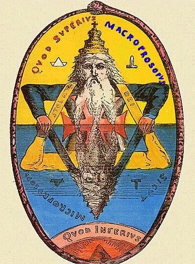
As your mind accepts your new reality, you slowly come to see the stars and the earth as the new above and below. You now understand the ancient phrase; : "AS ABOVE SO BELOW"
(View the image below in full size, magnify it, then scroll upwards slowly to get the effect. You get the full effect on a mobile phone)
Slowly things begin to become clearer to you. There never was a dome of the firmament. The 'dome' came about because humans have eyes that have convex lenses. Everything somehow seems to bulge and appear globular and spherical. The earth seemed to be a vast parallel plane realm with land both above and below, divided by the gaseous looking stars. This earth 'above' has its own sun and moon system. The waters of the firmament referred to the waters of the oceans in the earth realm above the one we have always known.
I wanted a definite reference to the globe heads spherical earth curvature. Since I didn't find one, I MADE one! In a 3d program, I created a sphere equal to the radius of the earth. Yes, the ball you see below in the image IS indeed 6371 km's in radius!! {My 3d program began to behave weird at this scale.) I had trouble placing the green box on top. But I managed it. The green box is 50 km in width and breadth, and height increases incrementally to show you the real curvature of the NASA spherical earth. (The top of the box is viewed always at eye level.) . You will note that significant curvature is seen only beginning at 50 km. (31 miles or 164,000 feet.) This is massive scale, which should not discount the fact that at small distances of a few miles you should be seeing objects at least a few 100 feet below the curvature. So if you see the bottom of a building across a 60-mile lake, then you are right in wondering what happened to the curve. The following renders give you an idea of the curvature you would see looking out from an airplane window, or a balloon door, or a spaceship portal.